Friday 17 August 2012

From wherever to Timbuktu....


Ever wondered where Timbuktu is, and how far it would take you to fly there from your home base ? Simply send an email to plogs@flylogical.com  with the following subject-line:

EGNS Timbuktu

For example, via gmail


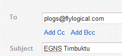
...and you will receive a PLOG with all the associated navigation route calculations  (as long as you have previously registered your email address with FlyLogical.com). I've used EGNS (Ronaldsway, Isle of Man) as my starting point since this is my home base, but you would specify whatever you like. The distance for me would be 2244 nm, and would take me 20 hours 56 minutes flying time in my Scottish Aviation Bulldog, requiring 6 fuel stops.

This (meant to be a fun) example demonstrates the combination of the latest powerful updates to iNavCalc. Namely, (i) the further-simplified email subject-line parser; and (ii) the addition of a global aviation waypoints database (courtesy of ourairports.com) which conveniently happens to include GATB (Timbuktu airport in Mali, Africa!).

Keeping it simple


Based on user-feedback, we have improved the iNavCalc email subject-line parser to incorporate a simplified route mode option. This enables you to specify your route by simply listing the waypoint identifiers, separated by spaces, as the sole content of the email subject-line. For example, a direct route from Los Angeles International to San Francisco International can be obtained by specifying

KLAX  KSFO

as the sole content of the email subject-line. For example, see screenshot from gmail:


Send this email to plogs@flylogical.com (no body-text required), and you will receive your pilots log (PLOG) and MET within seconds. Moreover, this route is 'sticky' and will be remembered in your following plog requests (until such time as you specify a different route via the email or web-browser interface). So, if you now send


you will receive a revised PLOG and MET for the same route (KLAX to KSFO) using the most up-to-date weather data. Likewise, by sending, for example


you will receive a PLOG and MET for the reverse route (KSFO to KLAX) using the most up-to-date weather data.


You can of course continue to use the more detailed command-line specifiers e.g.,

Route=KLAX, KSFO; ias=120; alt=5000


in order to combine with other attributes along with the route (see previous post for an introduction to the iNavCalc email  interface, and see the iNavCalc Users' Guide for a detailed description of all parameters available).

In combination with the recently-added global aviation waypoints database, you can now plan any route, anywhere in the world, via any device which supports email. Better still, it is completely free. You can also export your planned routes to your favourite moving-map app via email as long as the app supports the open-standard  GPX file format. See previous post with examples on how to transfer routes to/from SkyDemon and AirNavPro on the iPad.

For completeness, here's the same route displayed on iNavCalc's GoogleMap interface...


The world is your oyster


We have now added a comprehensive list of over 43,400 airports and 11,100 navaids across 242 countries to the FlyLogical iNavCalc global database. This enables you to plan your flight anywhere in the world via the iNavCalc email subject-line command interface, or the GoogleMaps web-browser interface. The global aviation data is courtesy of ourairports.com, a very useful (and free) community-maintained aviation web resource. If you wish to add or edit any entries, you can do so directly via ourairports.com. We will refresh the FlyLogical  iNavCalc database routinely, based on the updated ourairports.com database.

Here are some screenshots taken from the FlyLogical  iNavCalc GoogleMaps web app illustrating the newly-added airports and navaids (just visit flylogical.com to get started).

Accessing the database info within  iNavCalc GoogleMaps page

Use the Info tab (located near top-left of screen, oriented vertically, highlighted in following screenshot) on the iNavCalc Map page to access the panel for showing/hiding the airports, navaids (and other waypoints such as user custom waypoints, etc).


Example: Airfields in Scotland 


Example: Airfields in the vicinity of Chicago, Illinois, USA 


Example: Airfields in Germany


 Example: Navaids (VOR, DME, NDB) in New Zealand


 Example: Airfields and navaids (VOR, DME, NDB) in the vicinity of Johannesburg, South Africa


Example: Helipads in France


Bulldog checklist available for download

For anyone who flies the legendary Scottish Aviation Bulldog (like me), I've made the Flight Reference Cards ("checklist") available as a PDF download here (also listed under TECHNICAL RESOURCE LINKS on right-hand menu). Please feel free to grab it, use it, distribute it, as you wish.

I've styled the checklist based on the original RAF version (for the Bulldog T Mk1), with some modifications for the the post-RAF civilian version (Series 120/121), and with some specific adaptations to my own aircraft (G-BZFN) and usage-preferences such as "don't power on the intercom or radios until after starting the engine" (to avoid damaging the avionics with engine-induced voltage spikes), etc. You will recognize such changes as you read through the checklist.

Enjoy.

Thursday 16 August 2012

The Write Stuff...

Delighted that the UK General Aviation Safety Council (GASCo) published my letter summarising the key features of iNavCalc in a recent edition of their Flight Safety magazine. You can read the published letter under the subtitle Free PLOG Software in this extract from the magazine.

While we're here, I'll take the opportunity to correct a recurring typo in the article: namely, the correct email address to send your plog requests is plogs@flylogical.com  (rather than the incomplete plogs@flylogical quoted in the article).

For magazine circulation enquiries, contact penny.gould@gen-av-safety.demon.co.uk