Are you the owner /operator of a carpark ? If you were to provide the GPS coordinates of your lots, it would be a benefit to you by having exposure of your lots, plus a benefit to the Parking Radar community (iOS and Android) by having more complete coverage.
Here is a simple web-form for submitting GPS data.
Saturday, 16 September 2017
Parking your way to fitness
You don't need a car to participate in Parking Radar (for iOS and Android). When out walking, running, cycling, etc., whenever you see a parking spot not already on the map simply grab it (by tapping the I'M PARKED HERE button). Takes only a few moments, and helps everyone by enhancing the database by including more and more potential parking spots -- and good for you, too, if you do ever happen to get in a car again. You might get some funny looks when grabbing spots-- but it is surely worth it for the thrill of being plugged-in to The (Parking) Matrix. And remember to KEEP SAFE. You do not need to step on to the road to grab a spot. Anywhere within 3m (10 feet) of the spot will do fine.
Guide to Parking Spot validity
Please only "grab" spots that meet the following criteria:- Must be a legal parking spot as defined by local laws and regulations
- Must be publicly available in principle, either free (including disc zones) or paid
- NO private driveways
- NO reserved parking spots (or spots restricted to clients of a specific business)
- Generally accessible all year, not just for special events
- Must be suitable for cars (i.e., not just motorbikes etc.)
Saturday, 2 September 2017
Sywell Formation Sectors
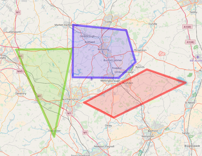
Click here for a moving-map browser app containing the Red, Green, and Blue Sywell Formation Flying Sectors for Chipmeet. I have transcribed them from these originals, available via the Chipmeet website.
This moving-map browser app (ReallySimpleMovingMap) can be used for in-flight situational awareness in the cockpit -- by displaying your current aircraft position relative to the sectors -- using any mobile device with a browser (e.g., iPhone, Android phone, iPad, etc). The app requires an internet connection to load and refresh the maps, but does not require an internet connection to track your position on the map once loaded (this just requires that you have Location Services enabled on your device). I therefore recommend that you load the map into your mobile browser, at the appropriate zoom factor, before you take off. Then with the map be pre-loaded, it will stay visible even if your internet connection fades when airborne. Here's what it will look like if you pre-load and zoom to allow the display of all three sectors.
This moving-map browser app (ReallySimpleMovingMap) can be used for in-flight situational awareness in the cockpit -- by displaying your current aircraft position relative to the sectors -- using any mobile device with a browser (e.g., iPhone, Android phone, iPad, etc). The app requires an internet connection to load and refresh the maps, but does not require an internet connection to track your position on the map once loaded (this just requires that you have Location Services enabled on your device). I therefore recommend that you load the map into your mobile browser, at the appropriate zoom factor, before you take off. Then with the map be pre-loaded, it will stay visible even if your internet connection fades when airborne. Here's what it will look like if you pre-load and zoom to allow the display of all three sectors.
"Turbine Legend" - Crazy, Beautiful, Thing
I was down at the Isle of Man airport grabbing some tools to fix my dishwasher the other day, when this crazy, beautiful, thing was parked next to my hangar. It is a "Turbine Legend" -- a US Experimental aircraft, on a ferry trip to its new owner in Germany, having just crossed the North Atlantic from the US.
- Tandem two-seat turboprop
- "Walter" engine, 724 SHP
- 275kt cruise
- 6000 ft/min climb rate
- 700 nm range with ferry tanks
- Approximately 50 of them in existence
- Pick one up for approximately $500 k
Spectacular looking machine.
Subscribe to:
Comments (Atom)


