This moving-map browser app (ReallySimpleMovingMap) can be used for in-flight situational awareness in the cockpit -- by displaying your current aircraft position relative to the sectors -- using any mobile device with a browser (e.g., iPhone, Android phone, iPad, etc). The app requires an internet connection to load and refresh the maps, but does not require an internet connection to track your position on the map once loaded (this just requires that you have Location Services enabled on your device). I therefore recommend that you load the map into your mobile browser, at the appropriate zoom factor, before you take off. Then with the map be pre-loaded, it will stay visible even if your internet connection fades when airborne. Here's what it will look like if you pre-load and zoom to allow the display of all three sectors.
Saturday, 2 September 2017
Sywell Formation Sectors
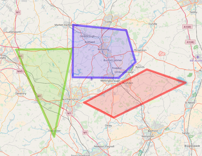
Click here for a moving-map browser app containing the Red, Green, and Blue Sywell Formation Flying Sectors for Chipmeet. I have transcribed them from these originals, available via the Chipmeet website.
This moving-map browser app (ReallySimpleMovingMap) can be used for in-flight situational awareness in the cockpit -- by displaying your current aircraft position relative to the sectors -- using any mobile device with a browser (e.g., iPhone, Android phone, iPad, etc). The app requires an internet connection to load and refresh the maps, but does not require an internet connection to track your position on the map once loaded (this just requires that you have Location Services enabled on your device). I therefore recommend that you load the map into your mobile browser, at the appropriate zoom factor, before you take off. Then with the map be pre-loaded, it will stay visible even if your internet connection fades when airborne. Here's what it will look like if you pre-load and zoom to allow the display of all three sectors.
This moving-map browser app (ReallySimpleMovingMap) can be used for in-flight situational awareness in the cockpit -- by displaying your current aircraft position relative to the sectors -- using any mobile device with a browser (e.g., iPhone, Android phone, iPad, etc). The app requires an internet connection to load and refresh the maps, but does not require an internet connection to track your position on the map once loaded (this just requires that you have Location Services enabled on your device). I therefore recommend that you load the map into your mobile browser, at the appropriate zoom factor, before you take off. Then with the map be pre-loaded, it will stay visible even if your internet connection fades when airborne. Here's what it will look like if you pre-load and zoom to allow the display of all three sectors.
Subscribe to:
Post Comments (Atom)


No comments:
Post a Comment