Friday, 28 February 2014

Long Live the File-System !

If you have spent much time building mobile apps -- or even using them -- you will know how painful it is to work around the lack of consistency regarding the treatment of file-systems across the various platforms. iOS is the worst. Last time I looked in any detail, the iOS file-system was heavily locked-down such that one is basically confined to the very limited sub-file-system associated with a given app: making it almost impossible to flexibly share files across apps, one of the best things about the file-system in the first place !

Android and Windows Phone 8 are better, but neither is as simple and effective as the good old desktop (or laptop). Perhaps that's one of the reasons why almost half of (the many thousands of) iNavCalc users, are still routinely using the "old-fashioned" desktop (laptop) web-browser version of the app (as opposed to the mobile versions). With the desktop (or laptop) browser, it is trivially simple, for example, to import and export GPX route files (via the Import/export button on the web-form), which happens to be one of the most commonly used features of the software.

I must admit I was a little surprised by all this. I had sort of assumed that the mobile versions of iNavCalc would rapidly outweigh the desktop version in terms of usage volume. But a year or so after releasing the mobile versions, the desktop still commands 50% (or so) of the daily action.

So, given these steady usage volumes on the desktop, I thought it would be good to spend just a little bit of time on improving the desktop version of iNavCalc. As such, and making good use of the file-system, I've enhanced the route file import/export functionality. Specifically, you can now do the following:

  • Import a GPX route file (this functionality was already present)
  • Import a Garmin FPL route file
  • Import a SkyDemon ".flightplan" route file
  • Export route to a GPX file (this functionality was already present)
  • Export route to a Garmin FPL file

These functions are all available via the Import/Export popup, as illustrated in the screenshot below.


Of course with the mobile versions of iNavCalc,  there is a workaround: namely exchanging files via email and via the Cloud storage functionality....but sometimes you can't beat the good old file-system in terms of simplicity and convenience. 

I  note in passing that the latest version of ChromeOS has a rather usable file-system. I was able to import/export route files via iNavCalc on the ChromeOS/Browser, with the same ease as I'm used to doing on Windows :)

Enjoy !


Sunday, 23 February 2014

Revenge of the Drones

Alas, my beloved quadcopter - complete with GoPro Hero 2 - featured in my recent post, has been lost at sea. It was unable to fight against the strong winds that carried it out to sea from the launch site in the Ramsey playing fields (Isle of Man).  Despite my best efforts to steer it to safety, the Irish Sea has claimed it.

An expensive lesson in the perils of flying beyond the weather limits of the aircraft...

Saturday, 22 February 2014

Bulldog Weight & Balance

I did some instrument flying refresher training the other day with an instructor plus a bunch of (heavy) documentation on-board. Got me thinking about weight & balance. Normally I fly solo so am well within the loading limits of my Scottish Aviation Bulldog, and hence I don't need to check routinely.

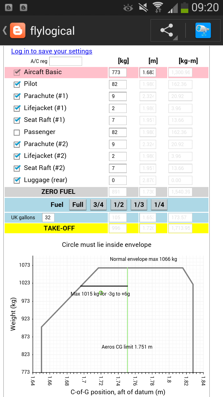
Anyway, when I was calculating the loading and checking against the charts and graphs in the Pilots Operating Manual, it struck me that this would be a very good example of a calculation well-suited to a web-app.

So I put one together (see screenshot below) and have published it for general use. You can find it here.

It is free to use. If you register with FlyLogical (also free), you can save (and retrieve) your settings across sessions.

Hope you find it useful.

Saturday, 25 January 2014

Attack of the Drones

My first attempts at shooting videos from a GoPro camera mounted on a quadcopter drone

Equipment list:


  • Walkera QR X350 quadcopter UAV ("drone") with GPS and compass
  • GoPro Hero 2
See pictures below.

Location: 

Laxey football pitch, Laxey, Isle of Man, British Isles

Conditions: 

Gusty

Videos:


Comments:


Profile for both flights: (1) manual take-off (via RC transmitter); (2) switch to autopilot stabilised mode after a few seconds airborne; (3) fly around a bit with guided steering inputs (via RC transmitter), whilst remaining in autopilot stabilised mode; (4) switch to auto-land mode whereby autopilot takes full control and lands the drone at point of take-off (GPS-driven).
   
The gusty conditions meant that the drone's autopilot was making frequent attitude and positional corrections, so the videos are not ultra smooth. That said. even without an anti-vibration camera mount, the quality is pretty good.

The auto-land feature was enabled. Even so, the landings were quite heavy: but perfectly survivable by both the drone and the GoPro.


Pictures


Wednesday, 1 January 2014

iNavCalc Data Sources

Updated 19 February 2015 to include openAIP.net source

Here is the current list of sources where iNavCalc gets its data. You will note that some sources are official, but since FlyLogical is not an official (re-)distributer of such data, all FlyLogical web-pages and apps carry a warning and disclaimer about not relying on the data without reverting to the original official sources.


  • METARs and TAFs:   US National Center for Atmospheric Research (NCAR) under sponsorship of the Federal Aviation Administration (FAA). This is an official data source. URL:  http://weather.aero 
  • NOTAMs: US FAA Aeronautical Information Data Access Portal (AIDAP). This is an official data source.
  • Atmospheric temperatures and pressures used in PLOG calculations: same source as METARs for surface data, then application of standard atmosphere model to extrapolate from surface measurements to flight altitudes. For each waypoint, data from the nearest METAR reporting station is used, so results must be considered as approximate.
  • Winds-aloft used in PLOG calculations: same source as METARs for surface data, then application of boundary layer model to extrapolate from surface measurements to flight altitudes (see http://es.ucsc.edu/~jnoble/wind/extrap/index.html ). For each waypoint, data from the nearest METAR reporting station is used, so results must be considered as approximate. Note: previous versions of iNavCalc utilised the NWX web-service ( http://www.navlost.eu/aero/nwx_help ) for deriving winds-aloft forecasts from the NOAA GFS models ( http://www.ncdc.noaa.gov/data-access/model-data/model-datasets/global-forcast-system-gfs ). However the NWX service has been intermittent of late, and no longer seems to be actively supported. As such, the alternate method of extrapolating from METAR surface winds has been adopted. This approach must be understood to be approximate,  not least since the boundary layer model is itself approximate. Moreover, an average value of 0.1 is assumed for the surface friction parameter in the model, thereby not taking account of local variations.
  • Geomagnetic declination: a local implementation of the World Magnetic Model (WMM), developed jointly by the National Geophysical Data Center (NGDC, Boulder CO, USA) and the British Geological Survey (BGS, Edinburgh, Scotland) . URL: http://www.ngdc.noaa.gov/geomag/WMM/DoDWMM.shtml
  • Solar angle calculations: local model based on Earth-Sun orbital model
  • Airport database: originally derived from the OurAirports.com community-maintained database, complemented thereafter by FlyLogical and by iNavCalc users
  • NAVAIDs database: originally derived from the OurAirports.com community-maintained database, complemented thereafter by  FlyLogical and by iNavCalc users
  • NAVCOM frequencies: originally derived from the OurAirports.com community-maintained database, complemented thereafter by FlyLogical and by iNavCalc users, and since 19 February 2015, automatically updated via openAIP.net on a weekly basis

Saturday, 16 November 2013

MET, NOTAMS, and Route Planning via Twitter

As a great fan of Twitter in terms of its concept and its technical implementation, when I was in the midst of rolling-out Version 3 of the iNavCalc mobile app, I got to thinking that it would be a fun mini-project to combine the Twitter API with iNavCalc. So that's what I've done.

The result is simple set of hashtags (#met, #notams, #route) which you can use to generate MET, NOTAMS, and routes directly from your tweets.  All you need is a Twitter account. To get started, see the simple instructions here.

Enjoy.

Saturday, 9 November 2013

iNavCalc version "Three Point Oh"

Version 3.0 of the iNavCalc mobile app has now been released.


Enhancements in V3


  • Load and Save Routes in the Cloud
  • Auto-open app when clicking on .GPX or .FPL files (Android only)
  • Share routes 
    • via Twitter (#ROUTEVIEW)
    • via Email
    • with other iNavCalc users (public or private) 
    • "Like" feature for voting as a "Cool Route" 
  • Various UI improvements and bug fixes


New features in V3


  • METARs & TAFs page with global ICAO lookup 
  • NOTAMs page with global ICAO lookup
  • "Cool Routes" page for displaying most-"Liked" routes 

An comprehensive Users' Guide is available here which describes all features of this latest release.

Sunday, 29 September 2013

Bulldog and Chipmunk Formation Meet

A couple of weeks after the last-ever Leuchars airshow, we took the Bulldogs to the BullChipMeet held at Sywell (EGBK) near Northampton, UK, over the weekend 22--23 September 2013. This event focuses on formation flying training. Here is my video and picture diary from the excellent two days flying, made more challenging due to the mixed aircraft types, the Chipmunk being less powerful than the Bulldog.

Here's the route (generated using  iNavCalc RouteView) we flew in to EGBK from EGSF where the aircraft were positioned after Leuchars.

Video Diary: 7-ship (5 Chipmunks, 2 Bulldogs) Formation flypast over Cranfield (EGTC)

Here's the route (generated using  iNavCalc RouteView) for the flypast.


Friday, 6 September 2013

RAF Leuchars Airshow 2013


A collection of videos and pictures from RAF Leuchars Airshow 2013. Posted in reverse-chronological order (homeward-bound, airshow day, arrival). Rather sad that this was the last ever Leuchars Airshow, but delighted and privileged to have been part of this little piece of history.


Videos from Bulldog formation flight home 8 September 2013


Here's the route (generated using  iNavCalc RouteView) we flew home. It took 3 hours 10 minutes in a 10 knot head-wind. Longest duration flight I've ever done in my Bulldog!

Videos from flightline 7 September 2013


Photos of flying display 7 September 2013


This collection of aerial shots was taken  by my friend JP Robertson


Photos from the flightline 7 September 2013


An assortment of pictures taken whilst walking down the flightline on 7 September


Bulldog Formation Arrival 6 September 2013

Some GoPro video clips taken from the cockpit of my ex-RAF Bulldog xx667 arriving at Leuchars in formation with Bulldog xx546 on Friday 6 September 2013.

...and the route we flew from Prestwick (EGPK) (generated using  iNavCalc RouteView)  to get here.

Pictures from the flightline 6 September 2013

Some photos I took on the flightline at RAF Leuchars after parking-up the Bulldog. The plane-spotters will know what these are !