Saturday, 22 September 2012

Greetings, SkyVector !

Update 18 April 2017: completely re-written iNavCalc mobile apps with streamlined command-line interface for iOS, Android, and Windows 10

Update 23 September 2015: now supports the recently-modified SkyVector URL (exported link) format

Update 15 March 2014: iNavCalc: a complete nav planning solution for SkyVector

Update: iNavCalc V3.0 mobile app now released

Update: iNavCalc now includes NAVCOM frequencies

Update: iNavCalc now includes NOTAMs

Update: related, see recently-added Route Viewer which further extends the route-sharing capabilities of iNavCalc...

Always on the lookout for fun flying apps, I recently came across SkyVector . This is a very cool, free, web-based application which provides vectorised aviation charts with global coverage. You can define your own route via a simple waypoint entry dialog. At present, there is no flight-planning capability beyond the basic route-entry. However, you can simply copy-and-paste the list of waypoints from the SkyVector dialog into the subject-line of an email and send it to plogs@flylogical.com . A few seconds later you will receive a full VFR nav plan by email (click here for an introduction to this free service, and here for a detailed example).

Here's a worked example...

First open the SkyVector web-page (I used Chrome on a Windows 7 PC, in this example). Then specify your desired route as a sequence of space-separated waypoint identifiers in the Flight Plan dialog. In this example, I've specified the route from Newcastle airport (EGNT) to Isle of Man airport (EGNS) via Carlisle airport (EGNC) and the Dean's Cross VOR (DCS):


Press "Add". This will produce the following route in SkyVector:


To generate your Pilot's nav LOG (PLOG) -- including automated wind & weather, magnetic deviation, sunlight etc, copy-and-paste the list of waypoints into the subject-line of an email and send it to plogs@flylogical.com


In a few seconds you will receive an email with your PLOG as an attached PDF file. Here's the first two pages of the PLOG you will receive:


That's all there is to it !

Click here for another detailed example of using our free email nav planning service.

Enjoy !

A trip to Garmin's Toy Shop...

I was in Chicago on business a couple of weeks ago and happened upon the Garmin store. It's on the corner of Michigan and Erie...


What a fine place. The upstairs is best: full of aviation kit on display....


Knowledgeable and friendly staff. Took the time to describe and demonstrate all the devices I cared to look at.  As a result, I am now the happy owner of a 795...


A rock-solid unit, tons of features. Helped me through some nasty weather on the way back from Leuchars airshow last weekend. Perfect size. Fits tidily in my Bulldog cockpit via the versatile hefty clamp supplied in the box. Goodbye iPad (at least as a moving-map)...


Tuesday, 18 September 2012

Bulldogs and Red Arrows in Newcastle

When we arrived at Newcastle (EGNT) on 16 September due to weather diversion from Leuchars, we taxied-in and parked adjacent to the Red Arrows, who also happened to be there overnight (following their display at The Great Northern Run)...


Video of Bulldog return flight from Leuchars

Video clip of Bulldog (G-BZFN) return flight from RAF Leuchars on 17 September 2012. I actually departed Leuchars on 16th, but had to make a weather diversion with overnight stop at Newcastle (EGNT). The next morning, I completed the return home (EGNS) from EGNT. This clip shows the cruise over the Irish Sea  at 10,200 feet with the Isle of Man just visible on the horizon...


Bulldogs at Leuchars

Our Bulldogs (G-BZFN aka XX667 and G-WINI aka XX546) on static display at RAF Leuchars Airshow, 15 September 2012.


Sunday, 2 September 2012

Programming routes into SkyDemon and AirNavPro on the iPad via email


In my previous post, I described the main steps I follow when planning a VFR flight. As an example, I planned my upcoming route from Prestwick to RAF Leuchars where I'll be exhibiting my Bulldog on the static display in the 2012 Airshow.

In my VFR flight planning, I use a mix of "the old" (map, ruler, etc) and "the new" (automated PLOG computation via iNavCalc, plus other internet resources for NOTAMs, etc., all accessed via my Samsung Galaxy S2 smartphone).

A notable omission from that post was the use of my iPad in the cockpit. I'll cover that topic now.

Like most private pilots these days, I use my GPS device as my primary nav reference on-board. Specifically, I use my (IFR-approved) Garmin GNS 430. Owing to the inconvenience of programming non-standard waypoints on this device, I tend to use the "Direct-To" function between successive major (standard) waypoints to monitor the progress of the flight, and mostly to ensure I avoid controlled airspace. Even when monitoring progress on the Garmin 430,  I fly the nominal headings as prescribed by my pre-planned PLOG (see STEP 2 in previous post), making ad hoc corrections for wind (that differs from the forecast in the PLOG), and making routine visual reference to my physical chart (line on map, STEP 1 in previous post). I also routinely look out the window for the corresponding relevant ground features (it is VFR, after all).

That said, there are some powerful, feature-rich VFR flying apps available on the iPad. Notably, SkyDemon and AirNavPro, which are two of the most popular apps (at least here in the UK and Europe).


...but first, a couple of caveats


 I do not use the iPad as a primary nav reference in-flight, owing to the fundamental lack of robustness of the iPad (very much a consumer media device, not a true avionics device). I do, however, use the iPad flying apps for specific functionality that is very handy but not absolutely essential i.e., I can continue flying my route even if my iPad falls over (as it tends to do, every so often).

Also, a non-insignificant consideration is that there is simply no room in my Bulldog cockpit to accommodate my iPad in permanent view throughout the flight. Instead, I have to store it between the seats and take it out to view on occasion. 

What I use SkyDemon for


I use SkyDemon on my iPad for the following:
  • Getting a list of frequencies for my route when I'm confident I will not require any IFR materials (in which case, I use full JeppView trip-kits). Although I find the SkyDemon export to be slightly clunky (since it does not render directly in PDF format), it is more convenient than JeppView for quickly retrieving a list of comms frequencies for purely VFR purposes. I do not use SkyDemon for airfield plates since it provides only the relatively crude AIP files.
  • Vertical nav sanity-checking. The "virtual radar" function is visually slick, and helps me to verify that my planned altitudes do, in fact, avoid CAS and terrain, as intended. 
  • A backup GPS-enabled moving-map when in-flight. I basically "play" with this in-flight, but do not rely on it due to the fundamental non-robustness of the iPad. That said, SkyDemon helped me considerably on my recent flight from EGNS to EGPK (see opening paragraph to previous blog post) when Prestwick approach asked me to "report Dalrymple". I couldn't find "Dalrymple" on my physical chart, it wasn't on my Garmin 430, but it was on the SkyDemon map, so I quickly adjusted my heading and flew direct to Dalrymple using the SkyDemon moving-map.

What I use AirNavPro for


I use AirNavPro on my iPad for the following:
  • A backup GPS-enabled  moving-map when in-flight. Again, I just "play" with this in-flight, but do not rely on it due to the fundamental non-robustness of the iPad. However, because AirNavPro incorporates the UK CAA 1:500k charts, I find it helpful for increasing situational awareness since I can quickly compare "one-to-one" with my identical physical chart. I somehow find this more natural than the SkyDemon vectorised charts (visually very attractive and appealling, as they are). That said,  AirNavPro wouldn't have helped me in locating Dalrymple !

Loading routes on to the iPad

Assuming I've already generated my route via iNavCalc's email interface, I will have received an email with the following attachments (as described in detail in the previous post, repeated here for convenience):


In the previous post, I described in detail the "PLOG_....pdf" and the "MET_...pdf" attachments. I'll now describe the "ROUTE_....gpx" attachment. 

As the filename suggest, this is just an XML file (in the open-standard GPX format) which encodes the route.  It is almost trivial to load this file into the iPad using either SkyDemon or AirNavPro. Here's how:

Within the iPad email app, click on the "ROUTE_....gpx" attachment. The GPX content will be displayed in the main window (human-readable XML script), and, moreover, can be "opened in" any supporting installed app (as per the usual iPad functionality for embedded email attachments), as shown below:


Selecting SkyDemon, will load the route as follows:


Likewise, selecting AirNavPro, will load the route as follows:


That's really all there is to it !

In summary

So, to recap from the start of the previous post to the present:

Starting with a simple iNavCalc email:


I can construct an entire route based on a list of waypoints (specified in a natural manner i.e., reading-off from the line I've drawn on my paper chart), then import the route in to my chosen (GPX-compliant) iPad flying apps in a couple of clicks. Viewed in this way, iNavCalc can be considered as a natural, efficient, shorthand way of creating routes for your favourite iPad flying apps. 

Leuchars airshow, here we come !


Flight route-planning the old-fashioned way -- almost...

Update 18 April 2017: completely re-written iNavCalc mobile apps with streamlined command-line interface for iOS, Android, and Windows 10

Update: iNavCalc V3.0 mobile app now released

Update: iNavCalc now includes NAVCOM frequencies

Update: iNavCalc now includes NOTAMs

Update: all described functionality now available via mobile app...

First, a big thank you to Prestwick Flight Centre for looking after our Bulldogs in the lead-up to the RAF Leuchars airshow where we will proudly exhibit them in the static display. We positioned the aircraft at Prestwick in August so we can maximize our chances of actually getting to Leuchars on 14 September 2012, given the vagaries of the British autumn weather (EGPK being considerably closer to EGQL than either of our home bases EGNS and EGSF).

I now need to plan the (VFR) route from Prestwick to Leuchars. I'm going to use a mix of old and new technologies, demonstrating the power of iNavCalc (and it's interoperability with other apps) along the way. Here goes...

STEP 1: Draw a line on the map 

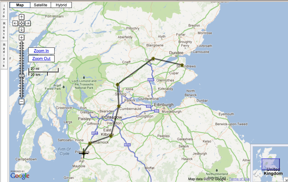
Call me old-fashioned, but I find the very best way of panning a route is to have the physical chart spread out on the table in front of me. In this case, the UK CAA 1:500k chart for Scotland. Also, I will need this the ultimate nav reference in the cockpit, in case the GPS fails or gets messed-up by jamming trials (an albeit rare but nevertheless possible occurrence). In case the weather is sub-optimal, I want a reasonably direct route which avoids Glasgow and Edinburgh Controlled airspace, avoids the most significant terrain, and which gives me some practical diversion opportunities along the way -- just in-case the weather closes-in. Inspecting the map, here's the set of waypoints I've come up with.

Navaid Altitude
1 EGPK (departure)
2 Road junction, south of Kilmarnock GOW188/16 2000
3 Strathaven microlight strip GOW139/16 2500
4 EGPG (overfly) 2500
5 Road junction west of Dunblane PTH237/26 2500
6 EGPT (overfly) 2500
7 EGQL (destination)

Importantly, I've included the radial(magnetic)/range(nm) of each waypoint from an appropriate radio navaid: again, in-case the GPS fails. I simply eyeball these from the chart using a protractor and a ruler (the CAA chart conveniently has magnetic compass-roses centred on each VOR, making the task of eyeballing the radials very simple). I've also shown nominal altitudes (in feet) which avoid CAS and terrain, again, derived from inspecting the chart.

STEP 2: Generate a PLOG ("Pilot's navigation LOG")

Let's recap. So far, I've used very old technology (map, ruler, protractor). With these, I've got a sensible route drawn on the chart which I will use in the cockpit as an essential nav reference if my GPS and radio navaids fail. I now want a PLOG which I can print out and use in the cockpit to monitor my progress with regards time, fuel (primarily) and diversion-planning. I will also use this PLOG (in combination with a stopwatch and chart) as my primary nav reference in the event that my GPS and navaids fail.

Rather than doing the calculations by hand (the old-fashioned way with whizzy-wheel etc), it is appropriate to now switch to using new technology. Nothing very fancy, however -- just my Samsung S2 Galaxy Android smartphone equipped with email. No other apps required.

Specifically, I now send the following email (via my smartphone):


You can see that I've simply specified the waypoint ICAO names and/or navaid radials from the above list, separated by spaces, on the email subject-line (i.e., Subject: EGPK GOW188/16 GOW139/16 EGPG PTH237/26 EGPT EGQL). That's it. A few seconds later, I receive the following response with the following attachments:


The first of these file attachments (named "ROUTE_..."), I'll discuss later. Let's focus on the second (named "PLOG_...") which contains the desired PLOG (our goal in this step of the planning). I'll extract and describe the pertinent sections from the PLOG PDF document below.

The first section is the FLIGHT SUMMARY, shown below:


This contains the key information summarising the flight at-a-glance. Importantly, it shows that as long as I depart on full tanks (32 UK gallons in my Bulldog), I will have plenty of margin (approximately 3 hours / 250 nm) in case I need to divert. It also shows that the expected flight time is 48 mins. Given that RAF Leuchars has specified a precise arrival slot time (12:20 local), this suggests I should aim to depart Prestwick at 11:20 local, giving 10 minutes margin (can always hold for 10 minutes if I arrive early).

The next section in the PLOG PDF doc is the NAVIGATION page, as shown below:


This contains the essential navigation information required for conducting the flight (headings, timings, fuel consumption for each leg). This would be essential for continuing to fly the route in the event of failure of GPS or navaids. Winds aloft are automatically retrieved from internet-based forecasts (valid at the point in time when the PLOG email was sent) and accounted for in the heading computations. Also, importantly, the "ETA/ATA" column has space for writing in (by hand) the actual times observed in flight so that the ETA's can be updated accordingly. Finally, the "Diversion available" column gives the (still air) range and endurance available from each waypoint along the route, should it be necessary to consider a diversion at any point along the way.

The next section in the PLOG PDF doc is the WAYPOINT DETAILS section, as shown below.


This contains the coordinates (latitude and longitude) of each waypoint, expressed in all common formats. This is useful for transcribing the non-standard waypoints into a built-in GPS device such as my Garmin GNS 430 (which, being IFR-rated, does not permit automated electronic upload of user data). Also displayed is the magnetic variation at each location.


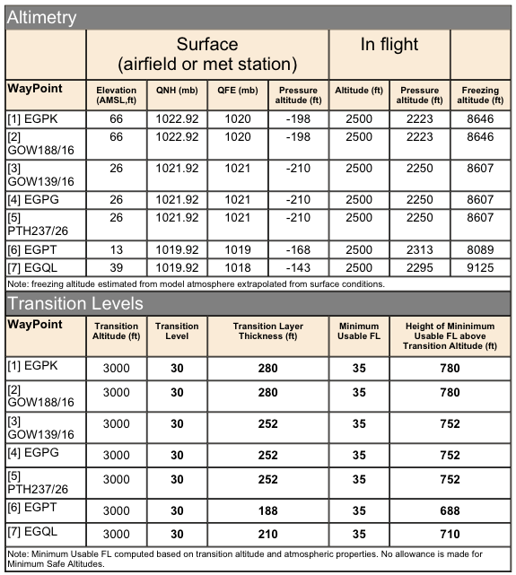
The next section in the PLOG PDF doc is the ALTIMETRY section, as shown below.


This shows the QNH (and QFE) computed for each waypoint location, computed via MET reports automatically retrieved from the internet (valid at the point in time when the PLOG email is sent). Importantly, the "Freezing altitude" column shows the (approximate) altitude when the outside-air-temperature  drops to zero degrees centigrade. The lower half of the page contains the TRANSITION LEVEL computations (note: requires the user to specify the appropriate transition altitudes along the route, defaults to 3000ft if not explicitly specified).


The next section in the PLOG PDF doc is the PERFORMANCE section, as shown below.


This shows density altitudes (at ground level and at flight altitude) computed for each waypoint location,  using data from MET reports automatically retrieved from the internet (valid at the point in time when the PLOG email is sent). This is useful for assessing the expected engine performance (especially important for takeoff and climbs). The lower half of the page shows the TAS (and Mach Number) along the route (for the user-specified IAS) computed for each waypoint location, using data from MET reports automatically retrieved from the internet (valid at the point in time when the PLOG email is sent).

The next and final section in the PLOG PDF doc is the SUNLIGHT section, as shown below.


This shows the sun position along the route, useful for determining if the given part of the route is in daylight or darkness. If daylight, the sun direction (as viewed from the cockpit) is shown, enabling the assessment of the potential for glare (and thus preparing for the associated hazards). The computations are based on the user-specified departure date/time (defaults to the point in time when the PLOG email is sent, if unspecified). The lower half of the page shows the sunrise, sunset, and hours-of-daylight for the date of the flight, computed for each point along the route.

STEP 3: Check the weather

Now let's turn to the third of the email file attachments (named "MET_..."). This is a PDF document containing the TAFs and METARS along the route, automatically retrieved from the internet, as shown below.


You can see that the MET stations in the report are automatically chosen based on their proximity to the route. There is no need to manually specify them.

STEP 4: Save the route 

Since I am pre-planning this route a couple of weeks before the date of the actual flight (on 14 September 2012), I want to save it so I can recall it on the day, and, more importantly re-compute based on the then-current weather.

It is simple to save the route in the FlyLogical database by sending an email as follows:

Note that the route specified in the previous email will be remembered (since I haven't updated it with a subsequent PLOG email request with different waypoints in the meantime). Now I am simply requesting that this previously-defined route gets saved in the database under the name "PRESTWICK TO LEUCHARS VIA PERTH". A few seconds later I received the following response:


The URL contained in the email ( http://bit.ly/PQXfi1 ) is a link to the saved route in the FlyLogical database. 

STEP 5: Re-compute PLOG on the day of flight

Let's recap. So far, the only actions I've taken were to (i) draw my desired route on my map; (ii) send a simple email to create a PLOG based on my desired waypoints; (iii) send a follow-up email requesting to save the route to the FlyLogical database for later use. Everything else has been done for me by the iNavCalc servers.

Now let's imagine we fast-forward to the 14 September 2012, the day of my flight to Leuchars. I want to re-compute my PLOG given current weather. To do so, I could simply carry out STEP 2 again (i.e., re-specify the waypoints on the email subject-line).
  
Alternatively, I can retrieve the previous email response and click on the link ( http://bit.ly/PQXfi1 ) to open the iNavCalc web-app (in the web browser on my smartphone, iPad, or PC etc), and load the previously-saved route into the GoogleMap interface, as shown below:


Opening the "Route" tab (left-hand-side) and clicking the "Get detailed PLOG..." button, opens a window from which the re-computation of the PLOG can be triggered, as follows:


Clicking the "Get PLOG by email" button will generate a PLOG delivered by email, as in STEP 2. 

The "PLOG_....pdf" (and "MET_....pdf", though less-compelling) file(s) from the email attachment can be printed-out for carrying on-board. I can also archive them on my smartphone (and/or iPad). Note: I find the Kindle app (from Amazon) to be particularly good for this, on both my Android phone and my iPad. I can simply email the PDF files to my Amazon Kindle account, then sync them to my portable devices, free-of-charge since the files are already in PDF format and do not need to be converted (for which Amazon would charge a small fee). I also use this approach for other PDF documents such as checklists, approach plates, airfield plates,  and whatever other useful references I wish to carry along without having to carry piles of paper.

STEP 6: Comms frequencies, airfield plates, approach plates

Now that I have my route and PLOG computations ready for flight, I need the list of relevant comms frequencies (radios and navaids), airfield plates, and approach plates (in case I find myself  in IMC and have to carry out an IFR approach). In my opinion, the best and most comprehensive source for these is Jeppesen JepView since they provide complete VFR and IFR coverage. I therefore prepare a Jeppesen trip-pack for the route, print it out "as PDF"  (using the excellent and free  Bullzip PDF printer app), and archive it (via the Kindle app) on my smartphone and iPad. I also take a physical printout of these just in case. However, I also have all the relevant frequencies within easy reach via my Garmin 430. They are also printed on the UK CAA chart. So, plenty of redundancy in this regard.


STEP 7: NOTAMs

My favourite source of NOTAMs for the UK is via the metutil.appspot.com website, a sample screenshot as shown below.


The reason I find this so useful is that it provides an at-a-glance view of the whole country, and I can zoom-in on the areas of interest, not just my nominal route. The SkyDemon iPad app (more on this in a later post) also has a powerful (and visually slick) NOTAM facility, but it is limited to the route in question, and it is therefore not very convenient for gaining a general overview e.g., when considering diversion pre-planning, etc.

STEP 8: Load route on to iPad

See my next post which covers this topic.

Saturday, 1 September 2012

VFR flight plans: are they worth filing ?

I recently posted this very question on the PPRuNe pliots' forum. Here's the thread. Bottom line seems to be that VFR Flight Plans are not considered very useful in the UK, but may be better elsewhere. Then again, given the ease with which they can be filed nowadays (e.g., http://www.eurofpl.eu/ ), probably worth doing. You never know, might be a useful 'get out of jail'...

Friday, 17 August 2012

From wherever to Timbuktu....


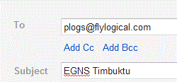
Ever wondered where Timbuktu is, and how far it would take you to fly there from your home base ? Simply send an email to plogs@flylogical.com  with the following subject-line:

EGNS Timbuktu

For example, via gmail


...and you will receive a PLOG with all the associated navigation route calculations  (as long as you have previously registered your email address with FlyLogical.com). I've used EGNS (Ronaldsway, Isle of Man) as my starting point since this is my home base, but you would specify whatever you like. The distance for me would be 2244 nm, and would take me 20 hours 56 minutes flying time in my Scottish Aviation Bulldog, requiring 6 fuel stops.

This (meant to be a fun) example demonstrates the combination of the latest powerful updates to iNavCalc. Namely, (i) the further-simplified email subject-line parser; and (ii) the addition of a global aviation waypoints database (courtesy of ourairports.com) which conveniently happens to include GATB (Timbuktu airport in Mali, Africa!).

Keeping it simple


Based on user-feedback, we have improved the iNavCalc email subject-line parser to incorporate a simplified route mode option. This enables you to specify your route by simply listing the waypoint identifiers, separated by spaces, as the sole content of the email subject-line. For example, a direct route from Los Angeles International to San Francisco International can be obtained by specifying

KLAX  KSFO

as the sole content of the email subject-line. For example, see screenshot from gmail:


Send this email to plogs@flylogical.com (no body-text required), and you will receive your pilots log (PLOG) and MET within seconds. Moreover, this route is 'sticky' and will be remembered in your following plog requests (until such time as you specify a different route via the email or web-browser interface). So, if you now send


you will receive a revised PLOG and MET for the same route (KLAX to KSFO) using the most up-to-date weather data. Likewise, by sending, for example


you will receive a PLOG and MET for the reverse route (KSFO to KLAX) using the most up-to-date weather data.


You can of course continue to use the more detailed command-line specifiers e.g.,

Route=KLAX, KSFO; ias=120; alt=5000


in order to combine with other attributes along with the route (see previous post for an introduction to the iNavCalc email  interface, and see the iNavCalc Users' Guide for a detailed description of all parameters available).

In combination with the recently-added global aviation waypoints database, you can now plan any route, anywhere in the world, via any device which supports email. Better still, it is completely free. You can also export your planned routes to your favourite moving-map app via email as long as the app supports the open-standard  GPX file format. See previous post with examples on how to transfer routes to/from SkyDemon and AirNavPro on the iPad.

For completeness, here's the same route displayed on iNavCalc's GoogleMap interface...


The world is your oyster


We have now added a comprehensive list of over 43,400 airports and 11,100 navaids across 242 countries to the FlyLogical iNavCalc global database. This enables you to plan your flight anywhere in the world via the iNavCalc email subject-line command interface, or the GoogleMaps web-browser interface. The global aviation data is courtesy of ourairports.com, a very useful (and free) community-maintained aviation web resource. If you wish to add or edit any entries, you can do so directly via ourairports.com. We will refresh the FlyLogical  iNavCalc database routinely, based on the updated ourairports.com database.

Here are some screenshots taken from the FlyLogical  iNavCalc GoogleMaps web app illustrating the newly-added airports and navaids (just visit flylogical.com to get started).

Accessing the database info within  iNavCalc GoogleMaps page

Use the Info tab (located near top-left of screen, oriented vertically, highlighted in following screenshot) on the iNavCalc Map page to access the panel for showing/hiding the airports, navaids (and other waypoints such as user custom waypoints, etc).


Example: Airfields in Scotland 


Example: Airfields in the vicinity of Chicago, Illinois, USA 


Example: Airfields in Germany


 Example: Navaids (VOR, DME, NDB) in New Zealand


 Example: Airfields and navaids (VOR, DME, NDB) in the vicinity of Johannesburg, South Africa


Example: Helipads in France


Bulldog checklist available for download

For anyone who flies the legendary Scottish Aviation Bulldog (like me), I've made the Flight Reference Cards ("checklist") available as a PDF download here (also listed under TECHNICAL RESOURCE LINKS on right-hand menu). Please feel free to grab it, use it, distribute it, as you wish.

I've styled the checklist based on the original RAF version (for the Bulldog T Mk1), with some modifications for the the post-RAF civilian version (Series 120/121), and with some specific adaptations to my own aircraft (G-BZFN) and usage-preferences such as "don't power on the intercom or radios until after starting the engine" (to avoid damaging the avionics with engine-induced voltage spikes), etc. You will recognize such changes as you read through the checklist.

Enjoy.

Thursday, 16 August 2012

The Write Stuff...

Delighted that the UK General Aviation Safety Council (GASCo) published my letter summarising the key features of iNavCalc in a recent edition of their Flight Safety magazine. You can read the published letter under the subtitle Free PLOG Software in this extract from the magazine.

While we're here, I'll take the opportunity to correct a recurring typo in the article: namely, the correct email address to send your plog requests is plogs@flylogical.com  (rather than the incomplete plogs@flylogical quoted in the article).

For magazine circulation enquiries, contact penny.gould@gen-av-safety.demon.co.uk

Saturday, 2 June 2012

Flying The Flag (& Flame)...

Took my British-built ex-Royal-Air-Force Bulldog T Mk1 up over Laxey, Isle of Man, today to get a bird's eye view of the Olympic torch procession as it passed through the village. Unfortunately, it was too misty to see much from 1500 feet, but later in the day I did manage to catch the air traffic control communication between the British Airways aircraft which couriered the flame to/from the island. Here are a few snippets of conversation between the Isle of Man controllers and "Speedbird 2012" as they departed the island for the torch's next stop in Northern Ireland.


Sunday, 22 April 2012

I can see your house from here...

Thanks to Google, the simplest way to find the coordinates of an arbitrary landmark (e.g., your buddy's house) is to use GeoSearch on Google Maps. Just type in the zip-code (or post code), or a name/description of the landmark, and Google's search engine will help you locate it on the map in seconds, anywhere in the world. iNavCalc's Google Map interface has an integral GeoSearch dialog, making it simple to discover and add such custom waypoints to your route. By contrast, most aviation navigation planning software tools only allow you to search the aviation databases to find waypoints (airfields, navaids, reporting points, etc). You have to add custom waypoints by first determining their coordinates (e.g., via Google Maps!, outside the tool), then manually typing the coordinates into the software.

Just another reason to add iNavCalc to your toolkit (and of course you can always transfer your iNavCalc routes to/from any other software which supports the GPX protocol)....

Saturday, 21 April 2012

Flight nav planning by email


A central and unique feature of iNavCalc is the ability to create a route and generate a navigation plan (PLOG) with nothing more than an email account. You can then seamlessly import the route (via industry-standard GPX format) into any device and/or software which supports the format. For example, SkyDemon, AirNavPro, and MemoryMap on the iPad. Here's a simple example:
  • First make sure you have registered online with FlyLogical. This is FREE, but you need to provide an email address for communicating with iNavCalc (make sure that your spam filter allows incoming email from no_reply@flylogical.com, and make sure that you follow the simple registration process to completion, including responding to the account activation email which you will receive during registration). You only need to do this once.
  • Now let's say you want to plan a route from Isle of Man (EGNS) to Prestwick (EGPK), with some intermediate waypoints based on VOR/DME radials. Specifically, the desired route description is as follows: from the starting point EGNS, fly heading 350 degrees for 20 nm, then navigate to the waypoint located 51 nm on the 348 radial from the IOM VOR, then from there, direct to the destination EGPK.
  • To create this route, prepare an email (say, on your mobile phone), using the subject-line to specify the route, as follows:
  • To: plogs@flylogical.com
  • From: <your email address as registered at FlyLogical, see first bullet-point above>
  • Subject: Route=EGNS, >350/20, IOM348/51, EGPK
  • Hit the Send button (make sure you have a connection to the internet)
  • A few seconds later you will receive an email containing a suite of attachments pertaining to the flight briefing for the route, including a PDF of the PLOG (based on actual winds aloft, atmospheric temperatures, and pressures) and a PDF of the TAF/METARS along the route.  Moreover, an attached GPX file containing the route can be opened in any device/software which supports GPX import (e.g., AirNavPro and  MemoryMap on Android or iPad, SkyDemon on iPad). (See previous post for information on interoperability via GPX with popular moving map apps).
  • As well as the route/waypoint info, there are many other options which you can specify on the email subject-line, e.g., altitude profile, aircraft performance parameters, etc.  For eample, specifying save=true will save the route to the cloud for later re-use. See the iNavCalc Users's Guide for details.
  • Finally, visit flylogical.com to access the iNavCalc Google Maps interface  (simple usage example here)
Have fun. Let me know what you think @FlyLogical on Twitter


Thursday, 19 April 2012

Storing your routes in the cloud...

Update: Version 3 of the iNavCalc mobile app now supports seamless interaction with the FlyLogical cloud storage functionality

Update: see recently-added Route Viewer which further extends the route-sharing capabilities of iNavCalc...

Here are a few tips and hints on how to use iNavCalc to store and share your flight routes in the cloud, independent of any hardware or software device. As a simple example, here's a step-by-step description of how to use iNavCalc to store and recall your  routes generated using the popular third-party SkyDemon app. I will assume you are using an iPad since, in my opinion, that is the most convenient platform for using such apps since you can take it into the cockpit and use it as a moving-map for real-time navigation as well as for pre-flight planning purposes.

The same general approach works for any iPad app that can handle emailed route files in the industry-standard GPX format (though originally there was a minor bit of work required to convert SkyDemon's legacy .flightplan format into GPX, the team at SkyDemon have now provided a direct GPX export for portability in their most recent upgrade on the iPad). With iNavCalc, you can therefore easily store & maintain your routes centrally (in the open-standard GPX format), and share them with specified individuals (or the whole world), and access them across your various favoured apps. So far I have successfully tested the GPX route import/export with the latest versions of SkyDemon (as described here), Air Navigation Pro, Memory-Map, and last but not least, iNavCalc.

The various apps all have their pros and cons, and you will probably find, like me, that you appreciate specific functionality from each of them. As such, your routes are yours, and you shouldn't be constrained by the confines of one tool or the other in doing what you want to do in the management, planning and navigation of your routes. That's my second motivation for providing this FREE web-based cloud resource. My first is that I wanted this functionality for my own convenience and interest!

Here goes. Hope you find it useful. Let me know @Flylogical on Twitter...

A) Saving a SkyDemon route from the iPad to the FlyLogical cloud

  • First make sure you have registered online with FlyLogical. This is FREE, but you need to provide an email address for communicating with iNavCalc (make sure that your spam filter allows incoming email from no_reply@flylogical.com, and make sure that you follow the simple registration process to completion, including responding to the account activation email which you will receive during registration). You only need to do this once.
  • Create a route in SkyDemon on your iPad
  • Select Route --> Send by Email  within SkyDemon
  • Address the email to: plogs@flylogical.com
  • Specify the subject-line exactly as follows (the save=true tells iNavCalc to save the route in the database under the specified name, can be whatever you like): save=true; name=My route
  • Make sure the From address is the same email address as you used to register with iNavCalc
  • Hit the Send button (make sure you have a connection to the internet)
  • A few seconds later you will receive two emails. The first will contain a suite of attachments pertaining to the flight briefing for the route (the usual iNavCalc generated response to any emailed plog request). The second will contain a link to the saved route in the iNavCalc database at flylogical.com. You can navigate via this link to the iNavCalc web app and view/manipulate the route in GoogleMaps. Notes: (i) if you have not yet registered with iNavCalc, or if you sent the request from an unregistered email account, you will only receive one response email (containing the flight planning docs); (ii) iNavCalc automatically converts the native SkyDemon .flightplan format into the industry-standard GPX format. Only the waypoint names and locations are converted. All other information is discarded.

B) Loading a route from the FlyLogical cloud into SkyDemon on the iPad via email

  • If you have just carried out Step A), as a test you can re-import the previously-saved route by email, as follows:
  • Send a blank email with no attachments to: plogs@flylogical.com  
  • A few seconds alter you will receive an email containing a suite of attachments pertaining to the flight briefing for the route (the usual iNavCalc generated response to any emailed plog request). iNavCalc will have remembered your last action and will conveniently recall your last saved route (since you submitted a blank request).
  • Scroll down the email and click on the first attachment which will be named ROUTE_******.gpx and activate the iPad "Open In" function (top-right screen icon), and select Open In "SkyDemon". Your route will be opened in SkyDemon.

C) Loading a route from the FlyLogical cloud into SkyDemon on the iPad via the web browser

  • Alternatively, navigate via your iPad browser to flylogical.com. Login using your registered credentials. You will be able to create/manage/edit/share all your routes from the iNavCalc web app.
  • Go to the iNavCalc map page
  • Create or load a route (using the iNavCalc on-screen widgets and functions)
  • When ready to send the route to the iPad, click the Get detailed PLOG button (located about two thirds of the way down the route control panel to left of map).
  • Click the "Get PLOG by email" button
  • A few seconds alter you will receive an email containing a suite of attachments pertaining to the flight briefing for the route (the usual iNavCalc generated response to any emailed plog request).
  • Scroll down the email and click on the first attachment which will be named ROUTE_******.gpx and activate the iPad "Open In" function (top-right screen icon), and select Open In "SkyDemon". Your route will be opened in SkyDemon.


Saturday, 3 September 2011

As the crow flies...

Now that we've added powerful GoogleMaps functionality to iNavCalc (see recent post), here's a very simple quick-start tutorial which demonstrates the most basic iNavCalc map features on the simplest of navigation applications: namely to find the distance "as the crow flies" between two locations anywhere in the world .


(...as well as a serving as a very basic intro to iNavCalc maps, this demonstration is handy in it's own right since one is often faced with the question "how far is it from so-and-so to so-and-so" -- now you can get the answer quickly via any browser on any device for any locations in the world...)

Monday, 22 August 2011

Announcing iNavCalc Google map interface

We are pleased to announce a significant new enhancement to iNavCalc functionality: the ability to create and edit routes and waypoints using the convenience of Google maps. To get started right away, click here for layout optimised for desktops, and here for layout optimised for tablets (iPADs). No registration is required for access to the basic functionality. Registration required for access to full suite of features. Registration is FREE.


Key features of iNavCalc map interface:

  • Built upon Google maps with all the functionality that they offer such as global coverage, satellite photo overlays, etc.
  • Optional display of airfields, navaids, and user waypoints from the FlyLogical database. Selectable on a country-by-country basis to avoid clutter and to minimise browser load time.
  • Powerful search widget for searching the FlyLogical waypoints database as well as the global Google database. If no match found in the FlyLogical database, automatically performs a global Google GeoSearch. With this combination, you can find virtually any location in the world and use it as a waypoint in your route.
  • "Add to Route" button for adding any waypoint to the route with a single click.
  • Clickable map,  enabling any point to be selected via the mouse cursor (or touchscreen on tablet) by simply clicking on the map.
  • Latitude and longitude coordinate editors in a variety of commonly-used formats, enabling the map cursor to be precisely located (and a "move to" function enabling any waypoint to be "nudged" to the location of the cursor.
  • New waypoint can be added to the end of the current route, or can be inserted in any position along the route.
  • "Rubber banding" functionality enabling any waypoint to be clicked-and-dragged to any position (or precisely re-positioned via the lat/long input editors)
  • Toggle zoom function (convenient for quickly visualizing an airfield, then zooming back out)
  • Magnetic variation and sunrise/sunset times automatically computed for any point selected on the map.
  • "Quick plan" (assuming zero wind) calculations (distance, time, fuel) automatically computed and displayed in a banner at the top of the page whenever the route is modified. Parameters for the "Quick plan" (speed, fuel consumption, start fuel) are fully-editable (units are set via the iNavCalc Culture parameter, requires registration which is FREE)
  • "Traffic light" feature which automatically changes the colour of the quick plan banner depending on fuel consumed on route (green for less than 80% available consumed, amber for between 80% and 90% available consumed, and red for greater than 90% consumed). Provides an at-a-glance view of the fuel-plan for the route.
  • "Radials" feature for determining and specifying locations on the map based on radials from a specified centre-point position. Any number of radials emanating from any number of centre-points can be included on the route map. Radials can be specified as either "Magnetic" or "True". If "Magnetic", the magnetic variation of the given centre-point is automatically determined when computing the radial. For convenience, all radials are saved along with the route, for later re-use (note: route-saving functionality requires registration which is FREE).
  • Full integration with iNavCalc's comprehensive flight navigation planning functionality including AutoMETic. Simply click on "Get PLOG by email" to generate a comprehensive flight navigation plan (PLOG) including automatic computation of wind and temperature effects based on automated global weather reports and forecasts.  This provides a more detailed and accurate plan compared with the at-a-glance "Quick plan".  
  • Full integration with iNavCalc's Route and Waypoints Managers for saving routes and waypoints to the FlyLogical database for later re-use (requires registration which is FREE).


Saturday, 16 July 2011

Announcing iBulldog

Our newest free app, iBulldog, is now live. This is a niche application for owners/operators of Scottish Aviation Bulldog aircraft, enabling you to calculate the Fatigue Index ('FI') for your airframe.


The Fatigue Index ('FI') determines the available life remaining in the Bulldog airframe. It is calculated from measurements of acceleration obtained from the 'Fatigue Meter' instrument, recorded after each flight. In the UK, for continued air-worthiness under CAA rules, each Bulldog owner/operator is obliged to send the readings each year to DeHavilland Support Limited (DHSL) who compute the revised life-remaining, according to formulae devised by British Aerospace (formerly, Scottish Aviation) during the full-scale fatigue life tests conducted as part of the original certification of the aircraft in the 1970s. 


Our iBulldog app gives you the ability to assess the Fatigue Index at any time within a given year, i.e., before the next official evaluation by DHSL. The results are accurate to within 4 decimal places of the DHSL  calculations. By enabling you to predict (approximate) FI consumption (for a given set of assumed FI readings), the app helps you to assess, a priori, the relative effects on lifetime of, for example, aerobatics versus circuits & landings, or steep-turns/air-racing versus gentle aeros. Armed with this information, you can fine-tune your flying profile accordingly.